
New Zealand’s South Island is a poster child for natural beauty and outdoor adventures. It not only offers stunning natural landscapes but also plenty of opportunities to explore them in the form of hikes and treks. After all, a holiday isn’t just about staying inside your hotel rooms. It’s about going out and getting some fresh, non-polluted air. Hiking New Zealand South Island is an outdoor lover’s dream.
There are several hikes in New Zealand South Island that give you a chance to spend time in the lap of nature and enjoy the spectacular scenery around you. In this post, I’ll be discussing the best hikes in New Zealand South Island that you should include in your New Zealand itinerary.
Hiking New Zealand South Island
From scenic 30-minute walks to multi-day hikes, the South Island has a lot to offer. And it doesn’t matter whether you’re a professional hiker or a first-timer. There are appropriate hikes for everybody based on their fitness levels.
Since there are several hiking trails, it can get a bit confusing as to which one to choose for the best outdoor experience. But do not worry! I have compiled a list of the ultimate hikes in New Zealand South Island to save you the stress.
Hiking New Zealand South Island – 15 Best Hikes In NZ South Island
There are several things to do and see in New Zealand South Island but hiking remains the most popular activity among travellers. Hiking, in this part of the world, is also called “tramping”.
So let’s take a look at the top hikes in New Zealand South Island that you can go tramping to!
Moke Lake Loop Track
- Total distance covered : 6.1 km
- Total time taken : 2 hours
- Difficulty level : Easy
- Elevation gain : 155 m
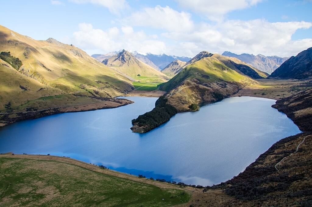
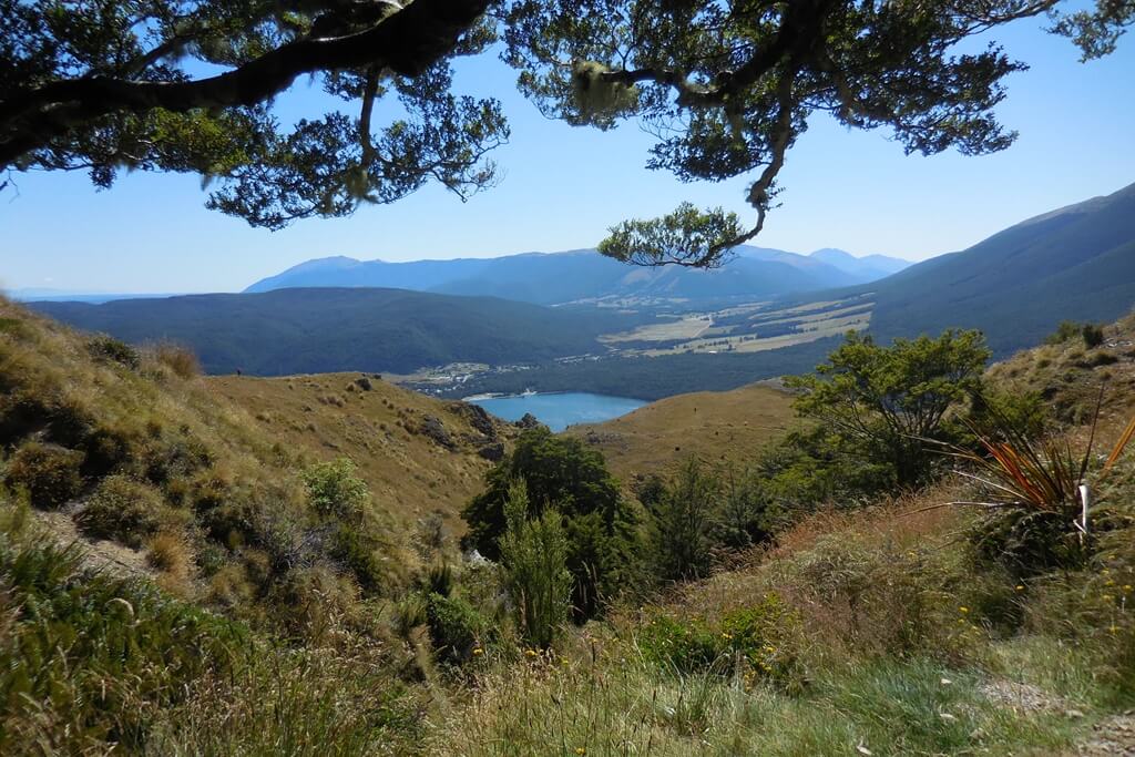
Moke Lake is a stunning lake situated near Queenstown. Here you can find the Moke Lake Loop Track, which is one of the easiest hikes in New Zealand South Island, with the trailhead right at the lake itself.
The trail is nearly all flat, leading around the lake, just with a little elevation. You can make it longer and hike up to the mountains to see the interesting shape of the Moke Lake.
The walking trail through grassland is surrounded by mountains and goes right around the lake.
The best time to hike the Moke Lake trail is during the summer season, but thanks to it’s lower elevation, it can be done even in early spring and fall. You can easily walk it alone.
The trail is only a 15 minutes’ drive from the Queenstown downtown area, which makes it one of the best things to do in Queenstown.
To get there, follow the road to Glenorchy and turn right for the road signposted ‘Moke Lake Road’. There is a steep drive up, and the last 8 km stretch is the gravel road.
One of the best accommodation options nearby is the Muna Moke Queenstown vacation home. There is also a DOC campsite by the lake, where you can stay overnight.
Note: No dogs are allowed in the area.
Contributed by Adriana Plotzerová from Czech the World
Key Summit Track
- Total distance covered : 7.7 km (from The Divide car park)
- Total time taken : 3 hours
- Difficulty level : Easy/Moderate
- Elevation gain : 423 m
The Key Summit Track is one hiking track that you don’t want to miss if hiking New Zealand South Island is on your agenda. It isn’t easy to get to but it is well worth the effort.
Located in Fiordland National Park in the South Island of New Zealand, the Key Summit Track makes up the first 3-4 km of the southern end of the iconic Routeburn Track.
The track starts at the Divide carpark which is located just over 80 km from Te Anau along the Te Anau-Milford Highway. From the carpark, you climb a total of 423 m while enjoying stunning views over the Hollyford Valley.
Once you reach a series of switchbacks, you know that you have almost reached the top.
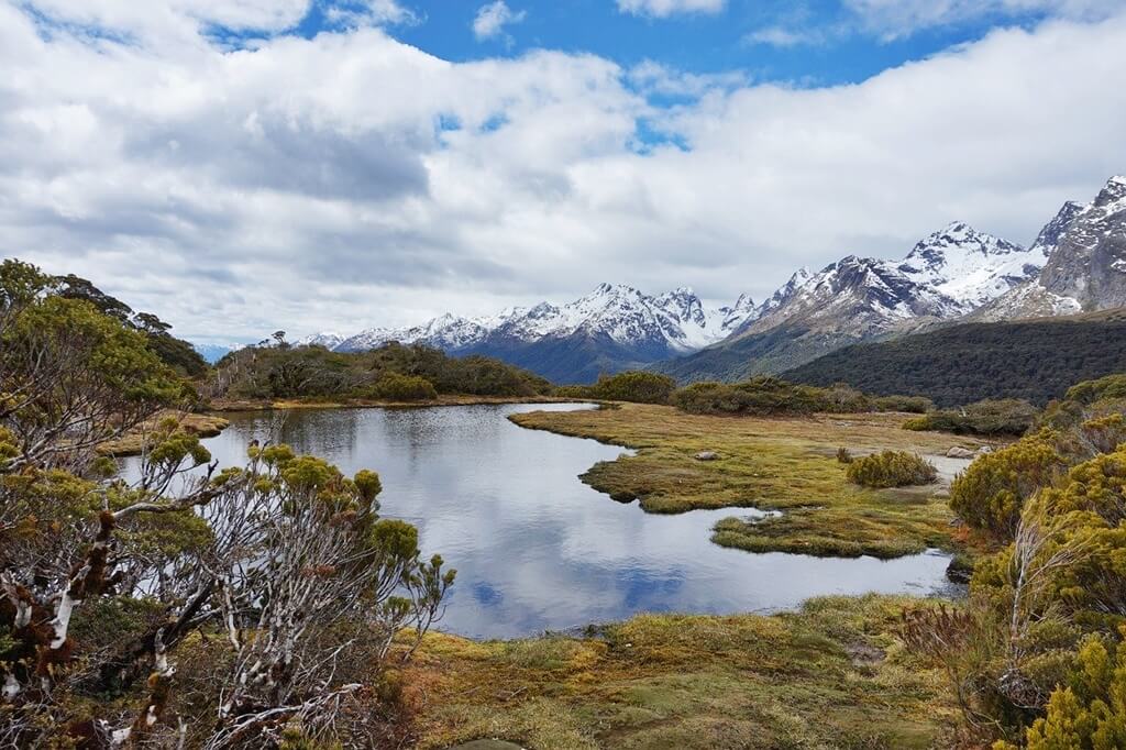
The final portion of the walk is a circuit called the “Key Summit Alpine Nature Walk”. It involves following duckboards through alpine bogs, tarns, and stunted silver beech.
From here, you are also treated to stunning views of the Darran Mountains and Lake Marian perched in the alpine basin between them.
The Key Summit Track is well maintained – making it an enjoyable, easy/moderate half-day hike.
There is no camping in the Divide carpark but there are campsites along the road from Te Anau to Milford Sound. Cottage 45° South is one of the best accommodation options in the area.
Note: The Te Anau-Milford Highway is often closed in winter due to avalanches.
Contributed by Susan Gan from Thrifty after 50
Sealy Tarns Track
- Total distance covered : 5.8 km
- Total time taken : 3.5 hours
- Difficulty level : Moderate
- Elevation gain : 550 m
The Sealy Tarns Track starts as the Kea Point Track in the heart of Mount Cook Village.
You can get there on the stunning roadway that weaves along the edge of turquoise Lake Pukaki – it’s around an hour’s drive from the town of Twizel, and about four hours’ drive from the surf-washed NZ coast around Christchurch.
The start of the path is an easy, flat 2 km track. Then comes the sudden veer off onto the so-called ‘Stairway to Heaven’. That’s a zigzagging set of over 2,000 timber steps cut straight into the side of the Sealy Range.
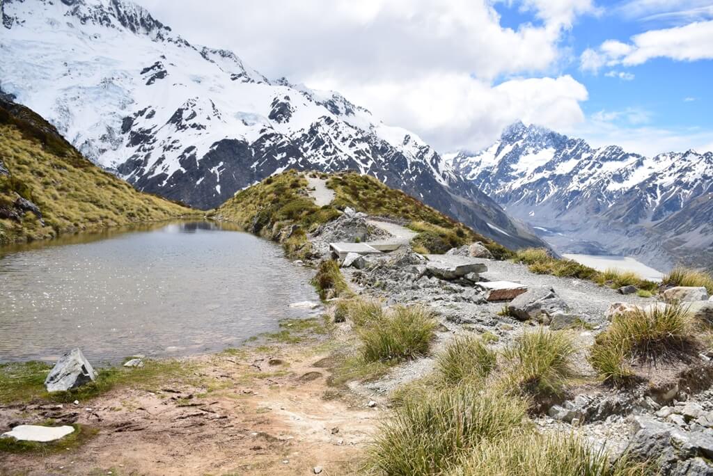
They’ll help you gain altitude fast, which means leaving behind the lush vegetation below for hardy alpine tussock and outcrops of rock.
In total, there’s close to 600 m of vertical gain on the stepped section alone. The reward is a small ledge where the eponymous Sealy Tarns – a series of reflective mountain lakes – sit under the shadow of avalanche-prone Mount Sefton and colossal Mount Cook across the Hooker Valley.
You can either relax at the lunch spot there or you can push on another couple of hours to Mueller Hut for an overnight stay in one of South Island’s most spectacular refuges (pre-booking is needed with the DOC).
Aoraki Mount Cook Alpine Lodge is one of the best stays near the Sealy Tarns Viewpoint.
It’s possible to do the Sealy Tarns Track in any season, although it’s considerably more dangerous with snowfall on the ground. Always check ahead in the Mount Cook i-SITE for track conditions.
Note: Avalanche risk and high winds on the exposed sections that link to Mueller Hut are particular hazards.
Contributed by Rich Francis from SurfAtlas
Lake Marian Track
- Total distance covered : 6.1 km
- Total time taken : 3 hours
- Difficulty level : Moderate
- Elevation gain : 420 m
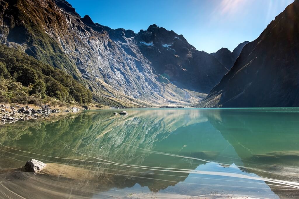
If you are looking for epic things to do in Te Anau, then hiking the Lake Marian Track just off the Milford Sound Road, has to be one of them. It is a rough, rocky climb through the bush to an incredible alpine lake.
The lake is only accessible from this tramping track, making it such a hidden beauty. The lake is often bathed in shades of green and is icy cold, so swimmers beware.
The return track is 6 km long and while only short, it’s a steep uphill climb, mostly on rocky footing (altitude gain of 420 m). If you can imagine a dry river bed with decent sized stones, it’s like climbing this the entire way.
For this reason, hiking boots are recommended, although it is doable without, just be careful of those ankles.
The trail will take about 3 hours return, but allow yourself some time to admire the lake. You will be surprised how long you end up spending just enjoying the tranquility.
The Lake Marian Track is just over an hour from Te Anau on Lower Hollyford Road.
It’s one of the best half-day hiking trails in New Zealand South Island, that can easily be combined with your visit to Milford Sound. You can stay at the beautiful Milford Sound Lodge, the closest accommodation to Milford Sound.
Contributed by Jennifer Parkes from Backyard Travel Family
Mount Robert Circuit
- Total distance covered : 9 km
- Total time taken : 2.5-3 hours
- Difficulty level : Easy
- Elevation gain : 600 m
Located in Nelson National Park, this is one of the easiest and most scenic hikes in New Zealand South Island. There are some exposed trails, but they are all well marked and easy to follow.
The Mount Robert Circuit is a total route of 9 km, although you can extend it by walking further on towards the Angelus Hut. The elevation gain during the hike is about 600 m. New Zealand’s DOC says that this route takes 5 hours, but it’s easily walkable in about half that time.
Access the Mount Robert Circuit hike easily by travelling from St Arnaud, 88 km from Nelson. Mount Robert is 2 km from St Arnaud and the start of the Mount Robert Circuit is 5 km from the start of the road.
There is no public transport on this hike. Trails for the Mount Robert Circuit start from the car park. If the road is icy, then the Mount Robert road will be locked.
The hike combines two trails, Paddys Track and the Pinchgut Trail, all are easily marked and signposted. You’ll get stunning views over Lake Rotoiti, but this is rather exposed, so take lots of sunscreen with you and wear it; take water or a filter water bottle to fill up.
There may be potable water at the Bushline Hut but it’s not always the case. There are, however, streams en route.
You’ll find the KEA ski hut on the way – you can’t go inside this historic hut but can admire it from the outside. It was built by the Nelson Ski Club in 1931 and is rather pretty.
The Avarest Bed and Breakfast is a great place to stay in order to hike this route. It’s just 2 minutes from Lake Rotoiti and you can use their kayaks and bikes too!
Contributed by Sarah Carter from A Social Nomad
Abel Tasman Coast Track
- Total distance covered : 60 km
- Total time taken : 3-5 days
- Difficulty level : Easy/Moderate
- Elevation gain : 180-200 m
The Abel Tasman Coast Track is a hiking trail in the Abel Tasman National Park on the north coast of New Zealand’s South Island. It is considered one of New Zealand’s “Great Walks” and is one of the best multi-day hikes in New Zealand South Island.
The starting point is Marahau and it’s best to take a water taxi from there to Totoranui and hike the way back to Marahau in 3-5 days. For those who do not have much time, there are also very popular day hikes that still include the most spectacular sections.
Commercial water taxis or boat tours offer a pick-up and drop-off service. This way hikers can start at many points and be picked up again later from another bay. Combined kayak and hiking tours are also popular.
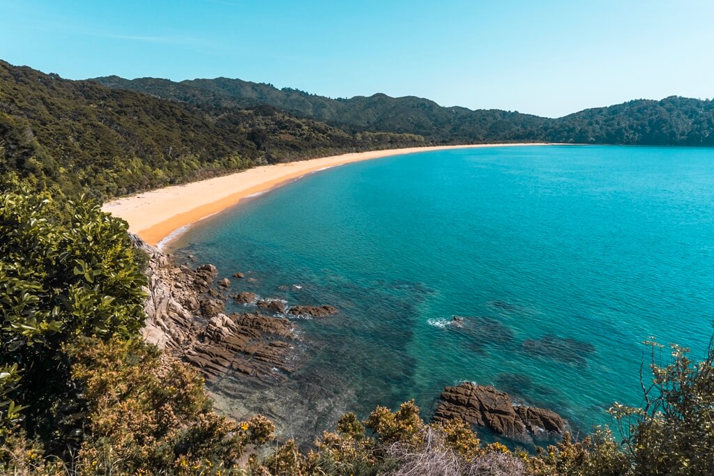
The hike leads past beautiful bays, through lush forests and bushland near the coast, crosses rivers, and runs along green waterholes and streams. Although there are some hills to climb up, at no point does the elevation feel really steep. It is a relatively flat hike.
The Abel Tasman Coast Track is one of the rare hiking trails in New Zealand South Island that can be hiked year-round. In the warmer months, it can get pretty busy. The best time to visit the park would be mid-winter, with the most stable weather of the entire year and no crowds.
There are four huts on the Abel Tasman Track – Anchorage (highly recommend!), Bark Bay, Awaroa, and Whariwharangi Bay. A stay in any of the DOC huts or campsites along the trail needs to be booked in advance.
If you’re looking for an overnight stay option before beginning the hike, then the Awaroa Lodge is the best accommodation near the Abel Tasman Track.
Note: It is crucial to check tide times on this track.
Contributed by Nina Kern from Plantiful Travels
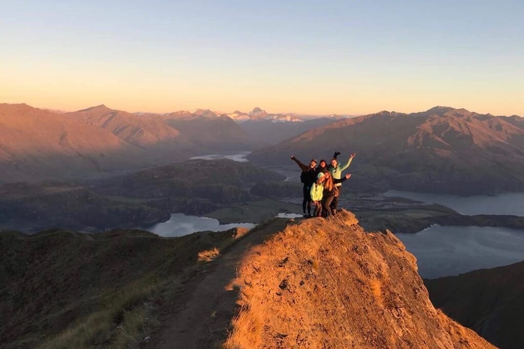
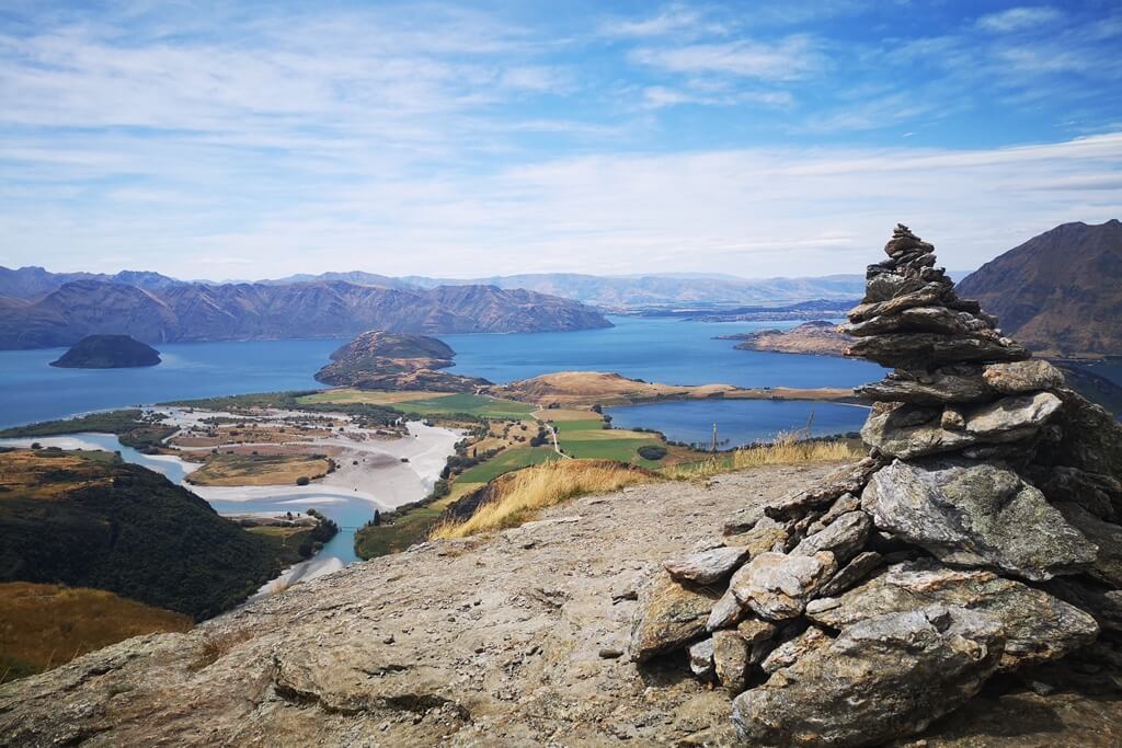
Roys Peak
- Total distance covered : 16 km
- Total time taken : 5 hours
- Difficulty level : Easy/Moderate
- Elevation gain : 1,250 m
Roys Peak is easily one of the most popular hikes in New Zealand South Island, made famous by photos of it’s lookout circulating on Instagram. Although busy, Roys Peak is worth the crowds.
The hike begins at the Roys Peak carpark, a short drive outside of Wanaka. Unless you are hiking Roys Peak for sunrise (which is highly recommended) be aware that there may be little to no parking available.
In the midday, consider walking from town or carpooling. At the carpark, there is a drop toilet, and this is the only facility available on the trail.
The trail is 8 km each way and has an elevation gain of almost 1300 m. The hike begins with a series of seemingly endless switchbacks.
The trail is worn and easy to follow, and the grassy meadows on either side make it difficult to stray off the path or get lost.
Towards the top, the hike gets steep in sections but is still manageable if you take your time. At the top, you will be surrounded by mountains on every side. There are tons of places to take photos (yes, including the iconic lookout).
Remember to wear proper hiking shoes and bring a backpack with plenty of water, sunscreen, and snacks. If it’s outside the summer season or hiking for sunrise, also bring a pair of mittens as it can be very cold and windy at the top.
Hikers with bad knees are advised to carry a pair of trekking poles, but it is not mandatory. Roys Peak can be hiked at any time of year, but special precautions should be made in winter.
There are tons of accommodation options in Wanaka nearby. For those outdoorsy or on a budget, the Glendhu Bay Motor Camp has exceptional views of the lake and is very affordable. And for those craving some luxury, the Mahu Whenua is an ideal place to stay.
Contributed by Mikaela Anne from Voyageur Tripper
Hooker Valley Walk
- Total distance covered : 10 km
- Total time taken : 3-4 hours
- Difficulty level : Easy
- Elevation gain : 120 m
The Hooker Valley Track in Mount Cook National Park is one of the best day hikes in New Zealand South Island due to it’s easy access along the Hooker River and incredible scenery.
The trail starts from the White Horse Hill Campsite (a 5-minute drive from Mount Cook Village) and gains only 100 m in elevation, which makes it suitable for all levels of fitness.
The walk has several viewpoints along the way and if the weather is clear, you will see Mount Cook in the distance. The trail takes you over three suspension bridges, but don’t worry, these aren’t the scary type!
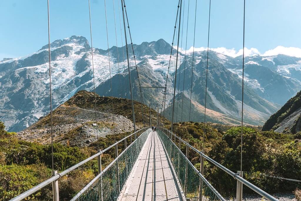
Your reward at the end is a view of the beautiful Hooker Valley Glacier Lake, which has several floating icebergs, having broken away from the nearby glacier.
The weather can change quickly in this area so it’s best to take extra layers of clothing and change/de-robe accordingly.
The trail can also be quite busy during the hot summer months so you might want to start early or late afternoon to avoid the crowds. Also, remember to carry plenty of drinking water with you.
If you wish to stay at a nearby accommodation, then Mount Cook Village has a handful of highly-rated hotels and hostels to suit all budgets – the YHA Mt Cook is excellent value for money, and The Hermitage Hotel is a lovely 5-star resort.
Contributed by Caroline Keyzor from CK Travels
Rocky Mountain Summit Track
- Total distance covered : 7 km
- Total time taken : 3 hours
- Difficulty level : Easy/Moderate
- Elevation gain : 412 m
The Rocky Mountain Track sits just outside the stunning town of Wanaka, and is undoubtedly one of the most underrated hiking trails in New Zealand South Island!
With an altitude of 775 m, it’s by no means the highest summit here, but it’s unmatched in terms of accessibility, outlandish panoramic views, and the shifting scenery that emerges around each bend in the trail as you move along it.
You get to the trailhead by driving (or cycling, or hitch-hiking- whatever takes your fancy!) 18.5 km west out of Wanaka along Wanaka-Mount Aspiring Road.
You’ll pass the remarkable Roys Peak on your left, skirt the wonderful Lake Wanaka, and eventually end up at a well-signposted car park on your right. The hike begins at the far end of it.
There are two choices here: a lower level circuit with good views over the lake and an upper-level circuit that takes you all the way to the summit. If you have a reasonable level of fitness, then the upper-level circuit is where the magic really happens.
Expect reasonably steep climbs (including stepped sections) through pristine Kiwi landscapes, a degree of exposure toward the top, and incredible views all the way!
The Rocky Mountain track is best-avoided in winter for the icy trails that develop. For the best hiking experience, head there during spring or summertime instead.
Whenever you go, be sure to wear good-quality footwear to protect your ankles over rocky terrain (the clue’s in the name, right?!), sunscreen to stave off sunburn under that crazy New Zealand sun, and plenty of water to last the entire 7 km, 3 hour round hike (check out these 75 things to take on a trip for more ideas on what to bring along).
Want to stay the night? The well-situated, widely popular YHA Wanaka (called the “Purple Cow”) in Wanaka town won’t let you down.
Contributed by Danny Newman from What’s Danny Doing?
Isthmus Peak
- Total distance covered : 16 km
- Total time taken : 4-6 hours
- Difficulty level : Moderate
- Elevation gain : 1140 m
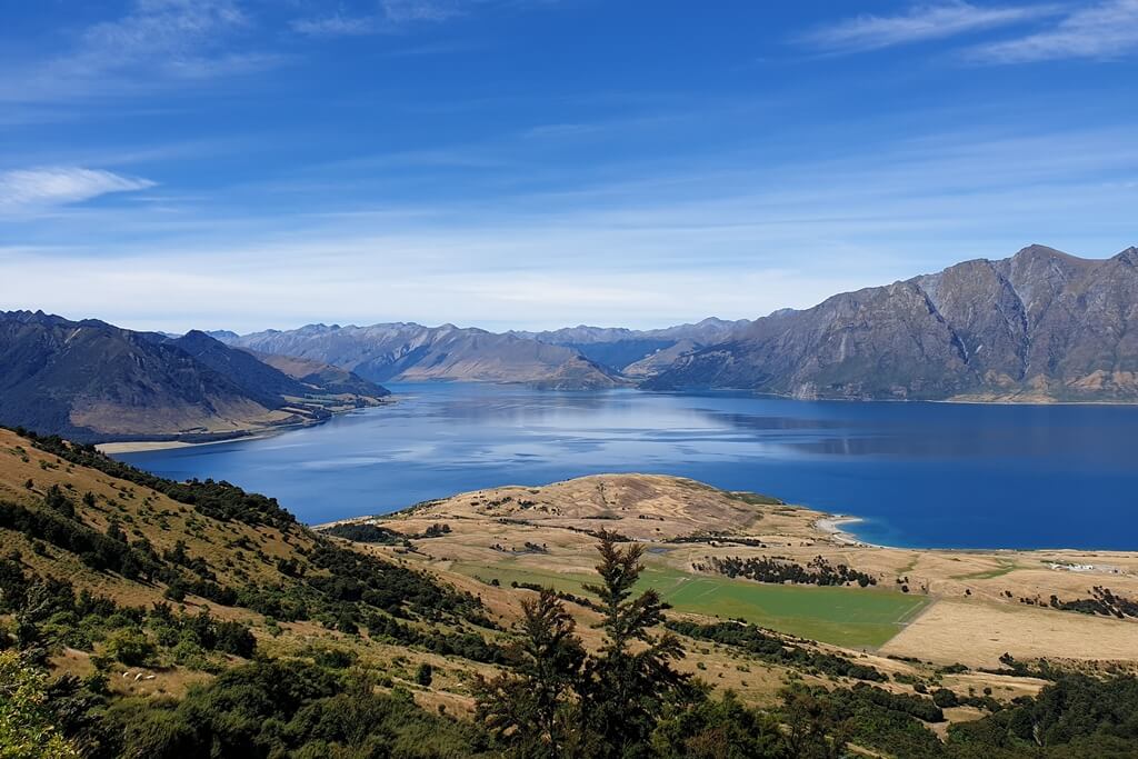
If you’re looking for an alternative hike to Roys Peak, then Isthmus Peak is for you. It’s located on the strip of land between Lake Wanaka and Lake Hawea.
With an elevation of about 1,140 m, it’s a steady incline most of the way until you get close to the summit when you walk along a relatively flat ridgeline.
On the way up, you have views of Lake Hawea throughout the hike, with minimal trees interrupting the views. It’s not until you get close to the summit that you get to see Lake Wanaka in all it’s glory.
You’ll most likely see some sheep along the way, which is always a satisfying sight when you’re hiking the South Island of New Zealand. Related to that, the trail is closed from November 20th-December 20th each year for fawning.
You don’t need a guide for the walk, so please respect these rules. And stick to the tracks, as tempting as it might be to chase the sheep!
The hike is best done in the summer. In the winter, there’s snow on the peaks which makes things harder and of course, colder. In the summer, get an early start or go later in the afternoon to avoid the time of the day when the UV rays are most dangerous.
There’s no public transport to the trailhead, so you’ll need to take your own transport to get there. Do not worry about the parking as there are ample parking spots next to the trailhead.
If you’re looking for a place to stay nearby, then The Camp – Lake Hawea is the perfect option for you. Here, you can hire a bike and go cycling or go fishing as well.
Contributed by Jub Bryant from Chur New Zealand
Truman Track
- Total distance covered : 1.4 km
- Total time taken : 30 minutes
- Difficulty level : Easy
- Elevation gain : 34 m
The Truman Track is one of the easiest and shortest hikes in New Zealand South Island. Located in the lush Paparoa National Park, it’s home to an extraordinary landscape.
From the car park just off State Highway 6, the track starts through a wonderful subtropical forest.
After a short walk, the path leads to a staircase that descends onto a secluded beach. There’s no accessible alternative, but there’s a viewing platform at the top of the staircase.
Both the beach and viewing platform provide breathtaking views of an otherworldly looking overhanging cliff.
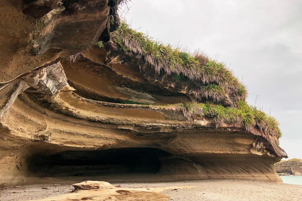
Carved out by water and wind, this large oval-shaped bluff is the main star of the Truman Track. It’s complemented by the small waterfall that streams down over the cliff straight onto the beach.
During low tide, it’s possible to cross a small strip of beach and explore the caves. But since it’s situated right on the shore of the fierce Tasman Sea, it’s advisable to always remain mindful of the fast-changing water conditions.
There’s no special gear needed for this track. But do wear sensible shoes as the wooden staircase and especially the large stones on the beach can get slippery.
You can easily get to the Truman Track by car. It’s located 52 km south of Westport and only 3 km north of the extraordinary Pancake Rocks and Blowholes Walk. At only a 3-minute walk, the Te Nikau Retreat is the nearest accommodation to the Truman Track.
Contributed by Zarina from Miss Travel Clogs
Peak Hill
- Total distance covered : 5 km
- Total time taken : 3.5-4 hours
- Difficulty level : Moderate
- Elevation gain : 600 m
Said to be the ‘Roys Peak of Canterbury’ but much easier, Peak hill trail is one of the most beautiful hiking trails in New Zealand South Island. With a 360° pano at the summit, hikers get stunning views of Lake Coleridge, the Rakaia River, and the impressive Southern Alps.
The track begins with a gradual ascent crossing private land and comes to a fence line. Look out for sheep or cows happily grazing nearby. The track from the first fence line to the ridge is the hardest part as the ascent is quite steep and can be slippery on the rocks.
Luckily, this only lasts about 40 minutes before hitting the ridgeline and then gradually climbing again to the summit. There are a few false summits but the views at the top are more than worth it!
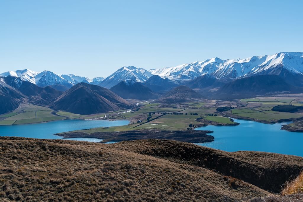
Peak hill stands at 1240 m, with a 640 m elevation over 2.5 km. It is open the entire way so double-check the weather conditions and be sure to have sunscreen, a hat, a wind/waterproof jacket, and sturdy hiking boots (absolutely essential).
Trekking poles are recommended, especially for the first part of the hike and coming down in that same area. Take extra care if hiking in the winter as the south side can get quite slippery with ice.
Getting to the Peak Hill trailhead is pretty straightforward. The trailhead is just under 2 hours from Christchurch heading west and is located about 6 km down Algidus Road in the Lake Coleridge area.
Algidus road is gravel, and there are often farmers out and about, moving stock or machinery, so be sure to pay attention while driving in the area.
The nearest accommodation is in Methven, 35 minutes away with a variety of motels and backpacker lodges. Abisko Lodge and Snow Denn Lodge are the best lodge stays in the area.
Contributed by Lauren Korstrom from Ponytail Pretty
Tasman Glacier And Blue Lakes Walk
- Total distance covered : 1.85 km
- Total time taken : 1 hour
- Difficulty level : Easy/Moderate
- Elevation gain : 100 m
The Tasman Glacier and Blue Lakes Walk is located just outside Aoraki/Mount Cook Village, which is a great place to stay if you want to start or end your day with this fabulous hike.
It’s a nice, short walk that will take you to the longest glacier in New Zealand (at 23.5 km), with an unbeatable view of the Tasman Valley below.
The Blue Lakes are actually green, and you can do short detours to those on your way up to the glacier view.
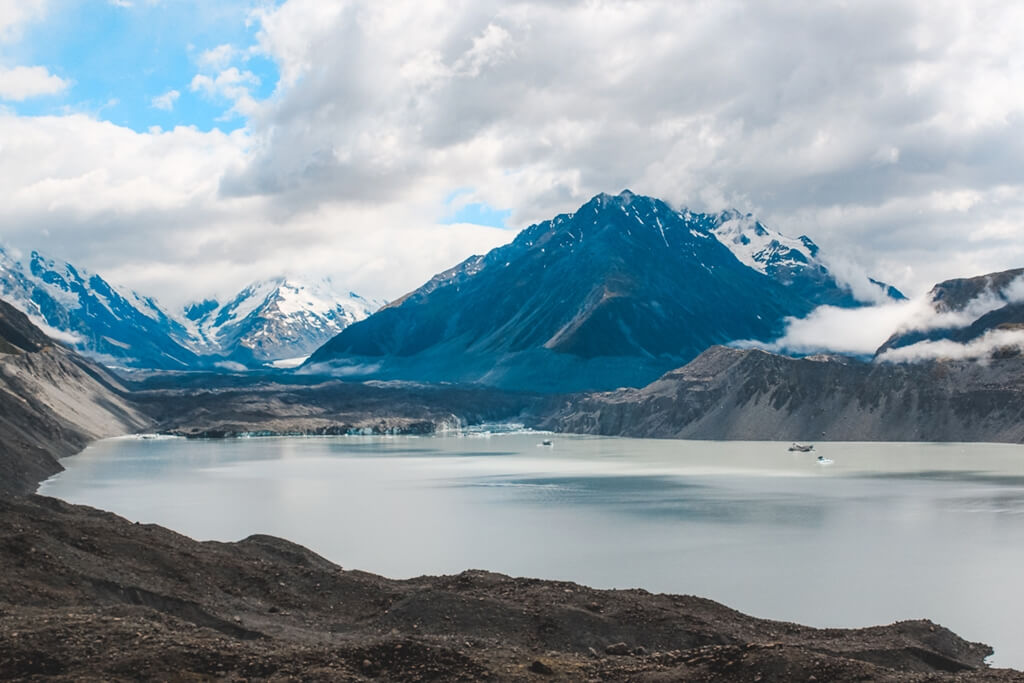
Since it’s a valley walk, the elevation gain is just 100 m. Though the trail is not that difficult, it can be a little rocky at a few places.
While you can’t get right up to the glacier, you can admire it from the viewpoint across the dreamy glacial lake which is still pretty amazing.
It is one of the best hikes to do in New Zealand South Island if you’re looking for something short or as a stop to stretch your legs on a long drive.
There is no need to do a tour here unless you want to do a heli hike, which would be pretty awesome, but not the most budget-friendly activity. There is no bad time to go, but the weather is perfect in January.
As for accommodations, the Aoraki Court Motel is an ideal budget-friendly stay option for both couples and solo travellers.
Contributed by Megan Johnson from Red Around The World
Queen Charlotte Track
- Total distance covered : 72 km
- Total time taken : 3-5 days
- Difficulty level : Easy
- Elevation gain : 470 m
The historical Queen Charlotte in the Marlborough Sounds is a lovely multi-day hike in New Zealand South Island where you can see the gorgeous native forest, stone beaches, birds, wildlife, and early settlements.
Queen Charlotte is a long, but not a hard walk. For a bigger challenge, try Antimony Mines or Mount Stokes side-tracks. Mount Stokes’ summit reaches 1203 m, and both are hikes of advanced difficulty.
As for the Queen Charlotte Track, the highest elevation is 470 m. If you’re feeling adventurous, then there are lots of hidden beaches to explore as well.
Popular activities include kayaking, fishing, glow-worms, and swimming. You will most likely see a curious weka on the track, as well as tui, kereru, and bellbirds. If you’re lucky, you might even get to see a little blue penguin.
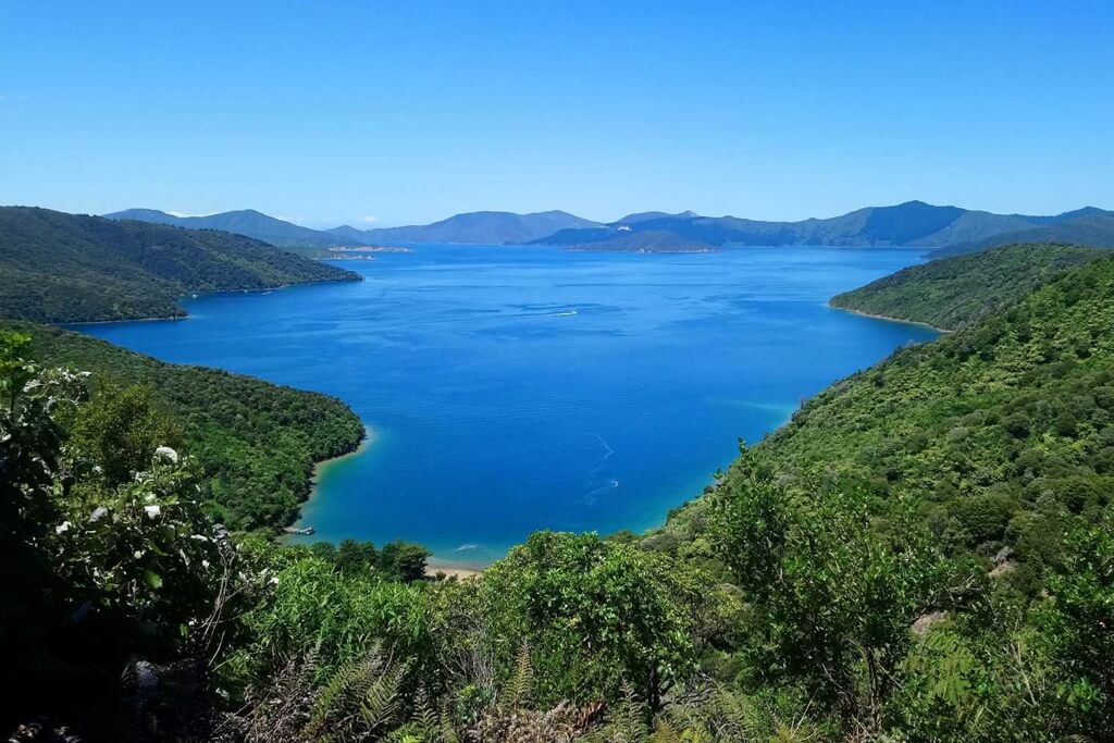
Dolphins (including the endangered Hector’s Dolphin) visit often, and fur seals laze about the rocks. Orcas and Humpbacks can be seen during winter.
Camping is available but restricted in some areas. The Furneaux Lodge is an amazing stay along the hike as it has al-fresco dining and a pub as well! Look out for honesty boxes near the track for some locally made produce (try the honey!).
To help the local economy, you can also choose to stay in a bach (a classic kiwi holiday house). You can book baches in and around Queen Charlotte Sound by clicking here.
Weather can change suddenly, and the track becomes more difficult when wet, so stay aware of the conditions around you. Summertime, especially around New Year’s, is the best time to do the hike.
To get to the track, take a water taxi (such as Cougar Line) from Picton to either Meretoto/Ship Cove or Anakiwa. Allow 3-5 days of walking, plus a couple days rest.
Note: Bring enough cash; Wi-Fi/EFTPOS isn’t guaranteed.
Contributed by Luke Wilkinson from CultureShock Adventure
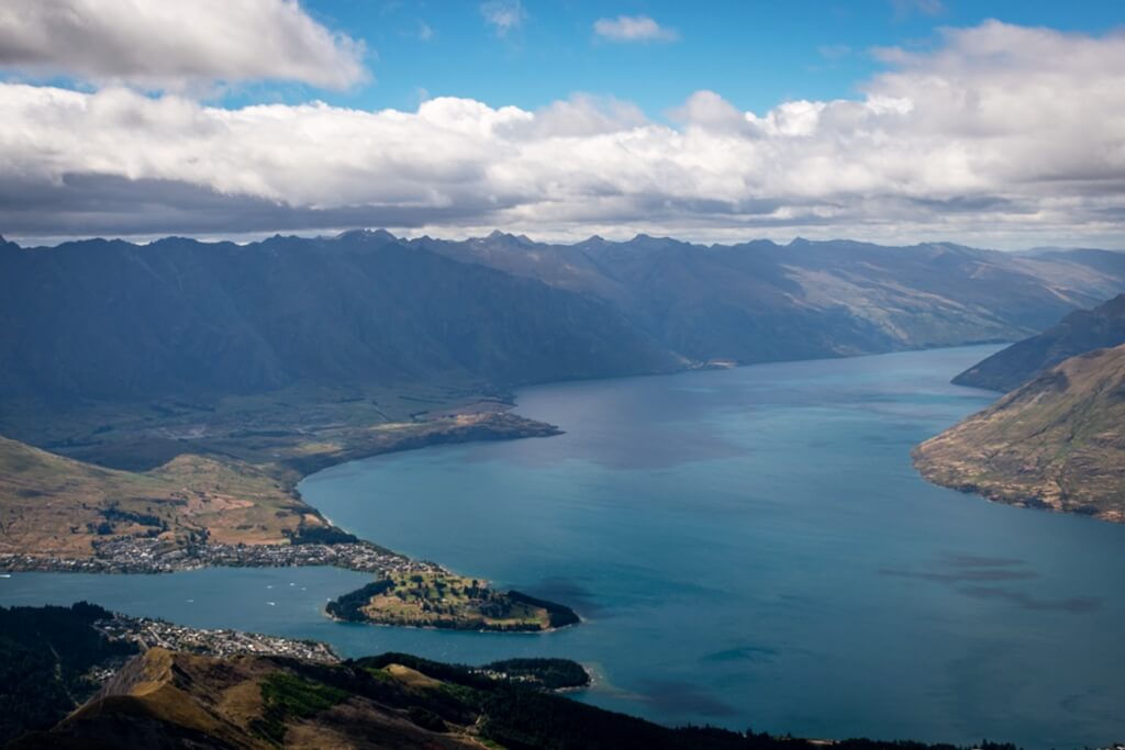
Ben Lomond
- Total distance covered : 11 km
- Total time taken : 6-8 hours
- Difficulty level : Advanced
- Elevation gain : 1,438 m
If you’re looking for a hiking trail in New Zealand South Island that’s challenging, then the Ben Lomond trail in Queenstown is certainly one to put on the list.
It may not be the easiest, but is surprisingly busy, and the views over Queenstown, Lake Wakatipu, and the surrounding mountains are amazing!
Standing at 1,748 m, the Ben Lomond hike requires a high amount of fitness for it’s steep 1,438 m climb. The track is open most of the way, so make sure to have sunscreen, a hat, and layered clothing with you as the weather in the area can turn very quickly.
It is a good idea to carry a head torch as well, in case it gets dark. Take extra caution in winter as alpine equipment is needed, the higher you go.
The path to the saddle is well-formed and a good turn around point if you’re not keen to head up to the summit. The track does intersect with mountain biking tracks at some points, so be careful for any bikers out on the path.
Once you reach the saddle, the climb to the summit gets steeper and rocky, so take your time while enjoying the beautiful views. You might even meet a Kea at the top!
There are a few different spots to start the track. The first, off of Lomond Crescent, the second, from the Tiki Trail on Brecon Street, and for the third, you can take a ride up the Skyline Gondola (buy a one-way or return ticket) and link up with the trail there to shave about 1.5 hours of the total hike time.
Queenstown has a variety of places to stay. The Canyons B&B and QT Queenstown are the best accommodations near the Ben Lomond Walkway. The area is very photogenic, so don’t forget your camera.
Contributed by Lauren Korstrom from Ponytail Pretty
Conclusion
So that was my comprehensive list of the best hikes in New Zealand South Island. I hope it gives you an idea as to what hiking New Zealand South Island is like. All of these hikes are safe and easy to do as long as you are honest with yourself with respect to your fitness levels and don’t try to bite more than you can chew.
Nothing beats the adrenaline rush you feel when you complete a hike. More than the satisfaction of completion, it’s the feeling of conquering the insurmountable which is addictive.
So if you’re planning a trip to New Zealand’s South Island, then don’t miss out on exploring it’s paradisiacal outdoors through these fantastic hiking adventures!
SHARE the post “Hiking New Zealand South Island – 15 Best Hikes in NZ South Island” with your friends, family, acquaintances, and travel buddies who love the outdoors.
PIN the image below to save it for future travel planning. Also SUBSCRIBE to The Wandering Vegetable for more such travel inspiration.
2 comments
Thank you for inviting me to take part in this collaborative post. There are lots of fantastic tips for hiking in New Zealand 🙂
Glad to have your valuable contribution. NZ is indeed a hiker’s paradise!